Hillforts of Gwent - In Search of the Iron Age
From a 2001 dissertation by Caroline Martin
Topography and History
of a Landscape
By Caroline Martin
First published 2001
To understand the importance of the sites discussed in this paper one must be aware of the landscape that surrounds them. Each site is within walking distance of the Gwent Levels. As yet the work being undertaken upon the Gwent Levels is still in its infancy and it is through the work of people such as Derek Upton, Stephen Rippon and Martin Bell that this area has been brought to the attention of the archaeological world.
The Gwent Levels are 111.2 square kilometres of reclaimed estuarine alluvium between the Rivers Ely and Wye in South East Wales. Formerly known as the Monmouthshire Moors, the area covers a coastal plain of twenty five kilometres (Bell et al, 2000 xxv). The area covers the fringes of the northern side of the Severn Estuary. The two largest Levels are at Wentlooge, which is situated between the Rivers Rhymney and Ebbw. The second Level is at Caldicot, which is situated between the River Usk, and the bedrock promontory at Sudbrook. There are other smaller areas of alluvium at Cardiff East Moors, between the Rivers Rhymney and Taff, the Level of Mendalgief which is between the Rivers Ebbw and Usk, and the St Pierre and Mathern/Chepstow Levels that are between Sudbrook and River Wye.
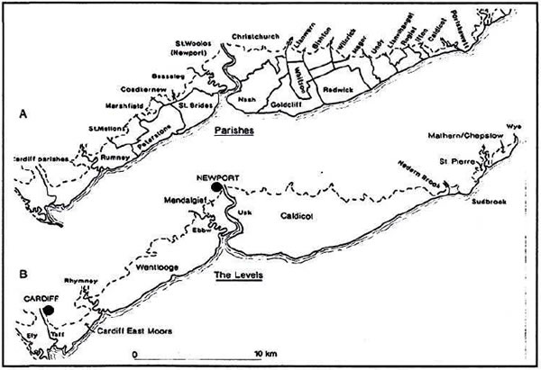
The Gwent Levels. After Rippon 1996
The Gwent Levels were created through gradual sediment deposition that occurred on the banks of the River Severn during post-glacial rises in sea level. The result of this created the largest reclaimed wetland in Wales and provides one of the most extreme examples of landscape totally crafted by mankind (Rippon 1996, 1-10). The whole area lies below the level of the highest tide and without the sea walls this area would be frequently flooded.
The Gwent Levels lie between 4.5 and 6.1 m OD, rising to 6.7 m (or more) towards the coast (WALSC 1954, 33-4). The exploitation of this area, added to its low lying-nature, has led to the need to control the water here. Two sources of flooding effect the amount of water converging with the Levels: firstly, the freshwater runoff that comes from the uplands, which receives between 0.9 and 1.0 m of rainfall per year, and then flows into streams and rivers and discharges the excess across the Gwent Levels; secondly, tidal flooding (WALSC 1954, 7). This landscape is extraordinarily diverse and the environmental and archaeological potential here are staggering. Sea walls have been constructed to stop the sedimentation of the reclaimed area, however, the mean sea level beyond the wall continues to rise annually (Rippon 1996, 1-10). Allen and Rae calculate that the sea level during the Roman period was between 1.6 and 1.7 m lower than today (Allen & Rae 1988, 225-235). Recent work carried out on the Gwent Levels has produced important archaeological material in both the intertidal zone and inland of the seawall. The present landscape is comprised of many features: major reens resulting from natural watercourses, major reens that are wholly artificial, inland abandoned sea banks whose origins are obscure, sea walls probably originating to the 16th century, gouts where the reens meet and coffer gouts where the reens cross, pills where the major reens discharge either into tidal channels or into the estuary itself, bridges that cross the reens and roadways built upon embankments, and finally numerous field systems which appear to belong to different phases of enclosure (Rippon 1996,1-10).
In relation to the buried, archaeological landscape there is archaeological evidence from every stage of history. Some examples of these finds are late Mesolithic human footprints, which were discovered, impressed into the lower Wentlooge Formation at Uskmouth. These prints were preserved in estuarine clay (Aldhouse-Green et al 1992, 14-55). Various investigations including bore hole data has been collated from along the line of the Second Severn Crossing and from the intertidal zone at Caldicot. This evidence suggests that the Neolithic and Bronze Age landscapes were environments with spatial and chronological variation (Allen 1992, 348-349). Bronze Age activity has been uncovered on desiccated raised peat beds at Chapel Tump on the Caldicot Level at Goldcliff, Iron Age activity is evidenced in the form of rectangular timber buildings, trackways and fish traps, which were discovered on a shelf of fen peat in the intertidal zone. Also nearby at Barland's Farm, Wilcrick, stone and timber structures dating to the Roman period and the remains of a third century Romano-British boat have been found (Nayling et al 1994, 596-603). The Barland Farm boat is in a remarkable state of preservation and after being conserved is part of an exhibition at Newport Museum.
WETLAND AND DRYLAND INTERACTION
The relationship between the Gwent Levels and the uplands surrounding it are not yet fully understood, the work undertaken here to date shows only limited evidence for activity during the Iron Age. Goldcliff Island has been the main focus of investigation. The lack of hearths and the paucity of the evidence available in this area raises many questions. It is possible that erosion has played a major factor in the lack of permanent structures; also the lack of substantial structures could imply the seasonal use of the area. Byres may have been erected during periods for temporary occupation to tend animals. The evidence however, does not wholly support this explanation; concentration of activity during this period appears to be away from, rather than near, the island and it is plausible from the evidence of the trackways that communications were more focused upon the open water and channels, rather than on the island itself (Bell et al 2000, 347-350).
The evidence we have would support seasonal pastoralism at both Llanmelin and Tredegar Camps, where there are contemporary appended enclosures of a type that is often associated with pastoralism. In this area there is recent evidence from Thornwell Farm, Chepstow of Iron Age activity (Hughes 1996). Other sites show Iron Age activity at Biglis and Caldicot, these have been dated to the Late Iron Age (Robinson et al 1988). The evidence of a relationship between the dryland and wetland in this area, can be compared to the Somerset Levels where each landscape facet contributes certain resources that were available cyclically (Bell et al 2000, 347). At Caldicot it would appear that during the Bronze Age, settlement may have been located at the edges of the wetlands and that by the Iron Age the main settlements had moved to the hilltops. Varying factors may have contributed to this shift in movement including the climatic down turn of the third century BC (Lynch et al 2000, 139-142).
MATERIAL CULTURE
Pottery is relatively rare throughout Wales during the Early Iron Age period, however, by the Middle and Late Iron Age traded pottery appears in the archaeological record (Earwood 1993, 20-45). Cunliffe argues that South Wales is usually known for its aceramic nature (Cunliffe 1991,100-118). However, there has been a limited amount of pottery found at sites including Llanmelin and Sudbrook, which are both on the edge of the Levels, whilst further inland, c.40 km north, Twyn-y-Gaer has produced pottery (Lynch et al 2000, 139-142). Lack of research throughout Wales for the Iron Age period means many aspects of the material culture within in the archaeological record is very unsatisfactory.
From the available evidence it is possible that the communities in the Early and Middle Iron Age of Wales were largely aceramic. However, Bell suggests that from the Late Bronze Age some groups were perhaps aceramic and built rectangular structures, whilst other communities were living in contemporary roundhouses and using ceramics (Bell et al 2000 347-350). Examination of the types of woods being used in the construction of structures upon the levels show that a variety of building techniques were being employed (Brunning and O'Sullivan 1997, 163-186). Outside influences could have been a factor in the changing methods that were being used or perhaps the people who were working with the wood simply discovered an easier way to exploit the materials that were available to them.
ORGANIC MATERIAL
Many organic finds have been recovered from the Gwent Levels, as the anaerobic conditions that exist here have led to the excellent preservation of bone, wood and textiles. Animal bones can tell us a lot about the economy of the people from this period. It would appear that there was an emphasis upon animal husbandry and the presence of neonatal and young animals suggests the importance of dairying. A bucket stave, a type that has been associated 8 with dairying, was found at Goldcliff, and is perhaps further evidence that dairying was taking place here. Examination of animal bones retrieved from Caldicot show that sheep and goat bones significantly outnumber those of cattle (McCormick 1997, 218-241). Lack of excavation upon inland sites in this area makes it difficult to compare any evidence that might exist. Comparison can also be hindered by the soil types of the surrounding area as the higher land around the levels consist of acidic soils and clays which are renown for their destructive qualities to organic materials. Excavation is needed here to ascertain if any structural evidence exists which in turn could help our understanding of the economy and settlement patterns of Iron Age communities in this region.
WIDER LINKS
The Bar land Farm boat has been dated to the Bronze Age. Sherrat has argued that there is possible evidence for major trade routes during the Bronze and Iron Ages with links between the Rivers Wiltshire and Severn (Sherrat 1996, 211-234). Bell, however, argues that the lack of material evidence in the inter tidal zones does not support this argument (Bell 2000, 347). The work being carried out upon the Levels is still in its infancy and therefore, we should be very wary of reaching conclusions about trade routes or any other aspects of Iron Age use of this area. As each major storm hits the Levels, new finds are discovered. The work that has already been undertaken upon the Gwent Levels has greatly advanced our knowledge. As research interest grows for the Iron Age in this region, hopefully the same amount of research will be accorded to sites inland of the Levels. The next chapters will concentrate upon sites in this inland area.