Hillforts of Gwent - In Search of the Iron Age
From a 2001 dissertation by Caroline Martin
Priory Wood Camp - Near Caerleon
By Caroline Martin
First published 2001
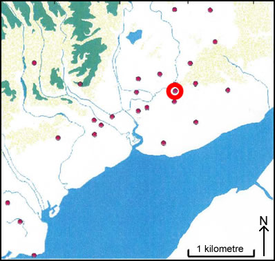
Location of Priory Wood Camp - Near Caerleon
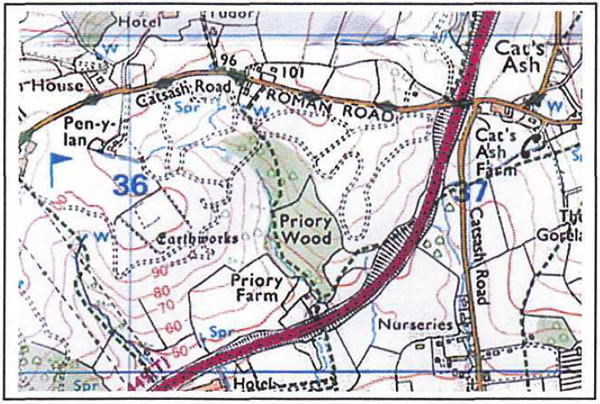
Priory Wood camp as seen on OS Explorer map 152
Image reproduced with kind permission of Ordnance Survey and Ordnance Survey of Northern Ireland
Priory Wood Camp (ST 361 905) is in the Parish of Caerleon and is 100m OD. The site is situated on the top of a hill overlooking the Usk Valley to the north and the coastal plain to the south. Permanently under pasture, the site shows slight traces of a square earthwork with what appears to be a smaller square inside. The whole site incorporates an area of approximately 1.6 hectares. On the north side of the outer earthwork, there are traces of a faint bank and ditch, which can be best defined at the north end. The bank is 6m wide to 0.2m high on the inside; 0.6m high on the outside with a slight outer ditch measuring 2m wide and 0.2m deep. There is a faint bank outside of this which measures 3m wide. At the southern end the bank takes a right angled bend towards the southwest and continues at a height of 0.6m. Outside the bank there is a berm that is 6 to 7m wide with a drop of 0.3m below it. The bank then turns at another right angle towards the north west. Along the south western end, inside of the bank is a depression of 8 to 10 m in diameter and about 0.8m deep. Along the north western side a ditch that is now overgrown with a hedge makes up the field boundary. Inside of the enclosure are what appears to be the remains of another square. The 27 south eastern side has traces of a faint scarp that is approximately 0.6m high and at the north western corner there are traces of a corner.