The Railways of Newport
By William J. Skillern, F.L.A.
From The Railway Magazine July 1960 No. 711 Vol. 107
By the end of the eighteenth century, the industrial revolution in the coalfield of South Wales and Monmouthshire had progressed so far as to require improved means of transport to the shipping ports on the coast. In the case of Monmouthshire, the nearest and most obvious place was Newport, situated near the mouth of the River Usk, and by an Act of 1792 the Monmouthshire Canal Company was incorporated and authorised to build canals and railways. These followed the course of two valleys, the Eastern Valley to Pontypool and Blaenavon, and the Western Valley to Risca and Beaufort, just north of Ebbw Vale.
The canals were opened in 1795-6, and ran from Newport to Pontnewynydd (11 miles), with a Western Valley section starting a mile from the southern end and running for another 11 miles to Crumlin; railways, built to a gauge of 3 ft. 4 in., continued northwards to Blaenavon Ironworks and to Beaufort Ironworks respectively. In 1800, Benjamin Outram recommended the substitution of tramroads made up of flanged plates with a gauge of 4 ft. 2 in. in place of the railways, and this change was carried out in the Western Valley, where the gauge was later increased to 4 ft. 4 in.
A second Act of 1797 allowed the canal to be extended below Newport to an inlet on the Usk known as Pillgwenlly, and this extension was built in sections. A third Act of June 26, 1802, authorised the construction of a 23½ mile tramroad from the canal terminus (then near Llanarth Street, a quarter of a mile below Newport Bridge) and from Pillgwenlly through Risca to Tredegar Ironworks in the Sirhowy Valley.
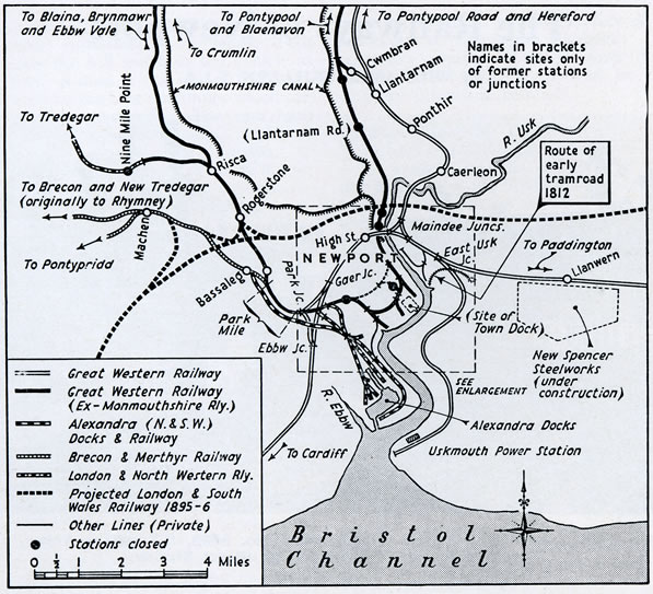
General map of railways serving Newport showing fromer ownerships
The two tramroads met at Courtybella, a mile from Newport, and after another mile entered Tredegar Park, a private estate belonging to Sir Charles Morgan. The 1802 Act empowered him to make and maintain the mile or so of track through his land and to receive the tolls therefrom. Thus was born the famous "Park Mile Railway," which remained the property of the Morgan family, whose later members became Baron and then Viscount Tredegar, until bought out by the G.W.R. in December, 1923.
The Monmouthshire Canal Company's ownership ceased 2½ miles beyond Risca, and nine miles from Newport, the line beyond being the property of the Sirhowy Tramroad Company. The peculiarly-named station of Nine Mile Point, closed in January, 1959, was three chains north of the spot marking the change of ownership of the tramroad.
It is generally accepted that the tramroad to Tredegar was opened in 1805, although the exact date is not recorded. In December, 1805, the canal company requested E. Jones of Risca not to build any more tram wagons like those he was then using, as they were injurious to the track. The tramroads were open to all comers, who provided their own vehicles and motive power (horses); toll houses were provided at intervals, as on turnpike roads.
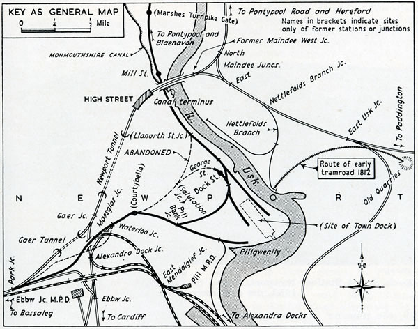
Railways in the neighbourhood of Newport
The Rumney Tramroad was projected in 1824 from the ironworks at Rhymney, in north-west Monmouthshire. Two sets of plans were deposited, one showing a junction with the Monmouthshire tram-road at Bassaleg, and the other continuing through Tredegar Park to a terminus on the bank of the Usk below Pillgwenlly, near the present Transporter Bridge. It was incorporated in 1825 and opened in 1836 to the junction at Bassaleg.
A horse-drawn passenger service between Newport and Tredegar was started about 1822 by John Kingson, who paid the toll demanded at each toll gate. A directory of 1840 lists five operators providing regular conveyance by tramroad from Moderator and Bristol Packet Wharves, near Llanarth Street, and Tredegar Wharf, at Pillgwenlly, to Tredegar, Rhymney and Caerphilly. There was, however, no through tramroad to Caerphilly, and it is most likely that Bedwas, on the way to Rhymney, was the railhead for that town.
By the 1830s, the canal had been extended to Pillgwenlly, and several branch tramroads had been built off the principal lines, chiefly to afford access to river wharves in the vicinity of Cross Street and George Street. In some cases, rows of houses were built beside the tramroad; indeed, the two sides of George Street remained separated by double railway lines until about 1930. Newport had its road traffic problems over a century ago, and the Corporation bye-laws of 1845, under the heading of nuisances, provided penalties for leaving any tram, cart, wagon, locomotive engine or other carriage on any tramroad where it crossed a street or other tramroad. Newportonians had seen their first locomotive on December 17, 1829, when a six-wheeled engine belonging to the Tredegar Iron Company travelled down the tramroad.
The Monmouthshire Canal Company was a prosperous undertaking, paying dividends of 10 per cent, or more for many years; but this was done by neglecting the maintenance of the tram-roads and charging high tolls for their use. The freighters who used the line became dissatisfied, and in 1842-3 projected their own Newport & Nantyglo Railway. This would have been a roundabout route. It was to begin near the Town Dock, and reach the level of Risca Road by a 1 in 13 incline, then continue via High Cross, Cwmbran and Pontnewynydd, through a tunnel of 1 mile 3 fur. to Abertillery, then north through Blaina to Nantyglo, a total distance of 21½ miles; all this for an estimated £320,000! Among the provisional committee were all the Monmouthshire ironmasters—Crawshay Bailey of Nantyglo, Brewer of Coalbrook Vale, Brown of Ebbw Vale and Sirhowy, and Johnson, Manager of Blaenavon.
The projected line was withdrawn when an agreement was reached with the canal company that it would complete the Eastern Valley railway down to Newport, improve the existing system and reduce its rates. An Act of 1845 gave the company powers to carry out the first two provisions, and also to adapt the whole system for locomotives and passenger traffic and to become carriers. The Park Mile had to be similarly improved by Sir Charles Morgan. An amending Act of 1848 changed the name of the canal company, which had hitherto been The Company of Proprietors of the Monmouthshire Canal Navigation, to The Monmouthshire Railway & Canal Company, and extended to August 1, 1849, the time for improvement of the track and provision of locomotives. The company intended to start public rail services to Blaina on that date, but a series of adverse reports on track, fences, signalling and points, made by Capt. J. L. A. Simonds to the Commissioners of Railways during 1849, resulted in their postponement.
At this time, the railway or tramroad system of Newport and Monmouthshire, although extensive, was quite isolated from that of the rest of Great Britain. Not until June 18, 1850, did a main line reach the town, when the 75 miles of the South Wales Railway were opened from Chepstow to Swansea. This was laid out by I. K. Brunel, and was built to the Great Western broad gauge of 7 ft. 0 ¼ in. A branch north-eastwards from Newport to Monmouth was authorised but not constructed, although there is evidence that earthworks were started near Caerleon. Brunei's bridge over the River Wye at Chepstow was opened on July 19, 1852, thus completing a through line of broad-gauge railway from Paddington through Gloucester to Newport and Swansea.
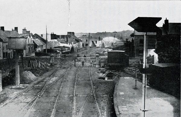
Looking past Thomas Street level crossing towards the railway bridge over the River Usk.
Note Brunel's GWR broad gauge of 7 ft. 0 ¼ in.
The passenger station at Newport was (and still is) within 100 yd. of the main street of the town, and took its name of High Street. It consisted originally of two platforms with three tracks between them and no overbridge. The tracks converged into two just east of the station, where there was a level crossing.
Within three years of the opening of High Street, four stations were opened by the Monmouthshire Railway, two of them being temporary ones. First to be provided was the temporary station at Courtybella, opened for the long-delayed passenger service to Blaina on December 21, 1850. This was sited a little to the west of the junction of the two earliest tramroads into Newport. Nothing remains of the station today, but the site is marked by a zero post from which distances in the Western Valley are measured. It was superseded on August 4, 1852, by a station near the Town Dock. This station, Dock Street, was reached by improving the existing tramroad along Cardiff Road and George Street. Until about five years ago, part of the original train shed and entrance hall could be seen, but now only one wall and a short platform remain.
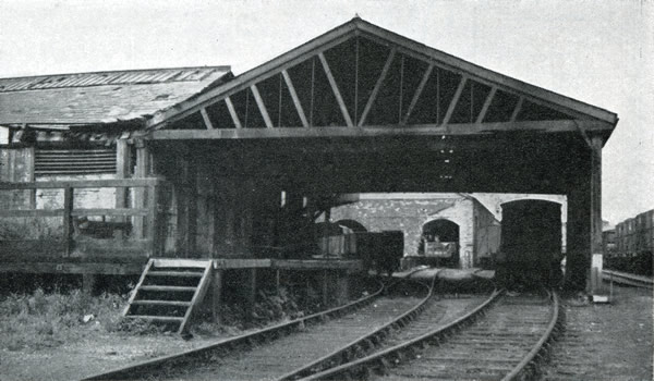
Dock Street Railway Station, Newport, closed to passengers in 1880, photographed August 4th 1952
the centenary of its opening
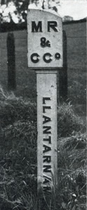 Boundary post of Monmouthshire Railway & Canal Company at Malpas, near Newport
Meanwhile, the Eastern Valley line had reached Newport on July 1, 1852, when a passenger service from Pontypool Crane Street was started to a temporary terminus at Marshes Turnpike Gate. This was the first railway of the standard 4 ft. 8½ in. gauge in the town. It was a single line eight miles long, and half an hour was allowed for the journey, with three intermediate stops. There were four trains each way on weekdays and three on Sundays; each day's service began and ended at Pontypool. No booking facilities were provided at Marshes Station, and a footnote in Bradshaw stated that "Passengers can only be booked at the Lock Office, High Street. An omnibus runs between the Lock Office and the present terminus at the Marshes Turnpike Gate." The station was removed when the line had been extended a quarter of a mile to Mill Street on March 9, 1853. This was the last Newport station to be opened, but there is little or nothing remaining today to indicate that it ever was used for passengers. The line was doubled in 1854 and extended northwards to Blaenavon, largely on the site of the canal company's railway of 1795.
At this time, each of the three passenger stations of High Street, Mill Street and Dock Street was served by trains of a different gauge—respectively, broad, standard and 4 ft. 4 in. (tramroad). The latter was converted to a standard-gauge railway by May, 1855, in which year the Mill Street line was extended southwards parallel to the canal for one mile to Dock Street, although the latter passenger station could only be reached after reversal, as today. Loops were also built from Dock Street to Pill Bank Junction, half-way between Courtybella and Pillgwenlly, and from Llanarth Street to Cardiff Road where the George Street line diverged. This last junction was known as Salutation Junction, after a nearby public house, and the section from Llanarth Street was on the site of the 1805 tramroad.
Although Mill Street and Dock Street were no longer physical termini, they continued to be used as terminal points for Eastern and Western Valley trains respectively. It seems strange that passenger services were not concentrated on one station (preferably Mill Street, which was quite close to High Street) or that Dock Street was not re-sited in order to bring both stations on to the same through line.
Direct rail access to the North of England was provided by the opening of the Newport, Abergavenny & Hereford Railway on January 2, 1854. In spite of its name, it did not start from Newport but at the junction with the Pontypool railway at Coedygric, nearly seven miles north of Mill Street. Beyond Hereford, the line to Shrewsbury was already open, and from there traffic could be sent northwards or eastwards by existing railways. A branch of the N.A.H.R. ran westwards from Pontypool Road over Crumlin Viaduct to a junction with the Tan0 Vale Railway at Quaker's Yard, and was opened in sections between 1855 and 1858. A Bill was before Parliament in 1853 to permit the sale or lease of the N.A.H.R. to the London & North Western Railway, which would undoubtedly have given that railway a sure foothold in Newport, but the Bill was dropped. Over 20 years later, the L.N.W.R. acquired the Sirhowy Railway in 1875, and Nine Mile Point became its nearest approach to Newport.
In 1860, the N.A.H.R. and the Worcester & Hereford Railway were vested in the Oxford, Worcester & Wolverhampton Railway, the name of which was then changed to West Midland Railway. Among the intended applications of this company to Parliament in 1862 were powers for "a station at Newport," but nothing came of this proposal. In July, 1862, the L.N.W.R. became joint owner, with the Great Western and West Midland, of the Shrewsbury & Hereford Railway, and therefore enjoyed the latter company's running powers over the former N.A.H.R. to Coedygric. A year later, these running powers were extended, by agreement, to Mill Street and the Town Dock. The L.N.W.R. passenger trains ran from Shrewsbury to Mill Street from 1863 to 1865, and again from 1875 and 1879. The running powers for goods traffic to Dock Street continued to be exercised for some 70 years afterwards, throughout the L.M.S.R. era and even after nationalisation.
The Brecon & Merthyr Railway was incorporated in 1859, and in 1863, acquired the Rumney Railway, which was the old Rumney Tramroad re-incorporated as a railway in 1861. Thus the Brecon & Merthyr inherited the Rumney's running powers between Bassaleg Junction and Newport, and on June 14, 1865, its passenger trains began to work into Dock Street Station; coal traffic followed in the next year. In 1865, also, through passenger trains between Sirhowy and Dock Street were authorised, the Sirhowy Railway being granted running powers over the Monmouthshire lines south of Nine Mile Point. In this way, these two inland railways obtained access to a port.
The South Wales Railway was amalgamated with the Great Western in 1862, and the West Midland followed suit in the next year. In May, 1872, the broad-gauge lines from Neyland through Newport and Gloucester to Swindon were converted to standard gauge, which already existed between Swindon and Paddington. This meant that, after 20 years, all the railways in Monmouthshire were of the same standard gauge and further developments were possible.
The Pontypool, Caerleon & Newport Railway, promoted by the G.W.R., was opened for goods on September 17, 1874, from Pontypool South Junction, on the former N.A.H.R. line from Pontypool Road to Coedygric Junction, to a triangular junction (Maindee North, East and West) with the G.W.R. on the east side of the River Usk. The original Act of 1865 gave the company power to take over the Caerleon Tramroad, which was in existence in 1812 and ran from Caerleon Forge to the canal at Cwmbran. It was intended that passenger traffic on the P.C.N.R. should begin on October 1, but after inspection by the Board of Trade inspector the opening was postponed until December 21, 1874, when a rather more direct line between Panteg Junction and Pontypool was also brought into use. From this date, four trains daily were run from Cardiff to Hereford and the North by the new route, and a change of station at Newport was no longer necessary.
The original route from the Western Valley, having passed through the Park Mile, crossed the main Cardiff Road by a level crossing near the point where the South Wales Railway was later built underneath, the road. The level crossing was removed in 1878, when the Monmouthshire Railway was diverted to cross the road by a bridge about 300 yd. away. In 1879, the G.W.R. opened a connecting line three-quarters of a mile long from Gaer Junction, west of Newport Tunnel, to Park Junction, at the end of the Park Mile, thus permitting Western Valley trains to run into High Street. Another line from Cwmbran to Llantarnam on the Caerleon route, gave a similar facility to the Eastern Valley.
High Street Station was rebuilt, with four tracks between the two patforms and the up platform made into an island. Into this enlarged station all trains from both valleys, including Brecon & Merthyr and L.N.W.R. (Sirhowy) trains, were run from March 11, 1880. Dock Street, Mill Street, Llantarnam Road and Cwmbran were then closed, the latter being replaced by a station a few yards away on the new line to Llantarnam. The two stations in Newport are still used as goods stations. Later in 1880, the Monmouthshire Railway was amalgamated with the G.W.R., after a close working arrangement lasting five years.
The opening of the Severn Tunnel in 1886 shortened the distance between Newport and Paddington by 15 miles and also resulted in the running of West to North expresses by the G.W.R. and L.N.W.R. In the past, some of these trains have reversed at High Street, but in recent years they have all travelled via the Maindee curve.
Increased trade and larger ships resulted in the Town Dock, nearly three miles up the Usk, becoming inadequate, and in 1875 a new dock nearer the river mouth was opened by the Alexandra (Newport) Dock Company. A second Act of 1882 provided for an additional dock, and also changed the name of the company to the somewhat portentous one of Alexandra (Newport & South Wales) Docks & Railway. The full Alexandra title took on its proper meaning in 1897, when the Pontypridd, Caerphilly & Newport Railway was absorbed. Newport was approached from two directions by railways with the initials P.C.N. This western one was in two parts, from Pontypridd to Penrhos Junction, west of Caerphilly (5¼ miles) opened in 1884, and from Bassaleg through Tredegar Park to the Alexandra Railway at East Mendalgief Junction (2¼ miles) opened in 1886; the intervening section was bridged by running powers over the Rhymney and the Brecon & Merthyr Railways. The Alexandra Company obtained powers in 1911 for a railway from Bassaleg to the L.N.W.R. at Nine Mile Point, but this was not built.
A passenger service between High Street and Pontypridd was started in 1887 with Alexandra rolling stock, and in 1899 the G.W.R. took over the working. It was suspended during the first world war, and afterwards restarted and extended to Merthyr until 1939, when it again terminated at Pontypridd. A Newport-Merthyr train ran during the winter of 1949-50, but did not appear in the public timetables; the Pontypridd service finally ceased on September 17, 1956.
The Great Western monopoly of London traffic was threatened in 1895-6, when there were proposals for a London & South Wales Railway. This was to start at a junction with the Barry Railway three miles south-west of Cardiff, and cross the Usk half a mile north of the G.W.R. bridge at Newport. It was then to run almost due east to Chepstow, cross the Severn estuary by a mile-long bridge, and continue eastwards to a London terminus near Edgware Road - within half a mile of Paddington! The Bill for this railway was withdrawn in 1896.
Railway development on the east bank of the Usk was much later and less extensive than on the west side. Ordnance Survey maps of 1812 and 1833 show an early "iron way" running for a mile in an easterly direction from the river bank to limestone quarries in the Somerton district. The writer has not been able to find any details about this tramroad, but it is a reasonable assumption that it carried the products of the quarries to a shipping place on the river. Various proposals were made for railways leading inland — in 1833 to Ebbw Vale, in 1837 to Abergavenny, and in 1865 to Pontypool Road, with a dock at East Usk.
The present four-mile branch from the main line to the coast was authorised by the East Usk Railway Act of 1885, and the powers to build it were transferred to the G.W.R. in 1892. It was opened in sections as a single line between 1898 and 1901, to serve several large steel works; an authorised junction from the east has not been made. It was doubled in readiness for the opening of the Uskmouth "A" Power Station, one of the largest in Europe, in October, 1953. Up to six coal trains a day are required to meet present demands, and this number will be increased when Uskmouth "B" is completed.
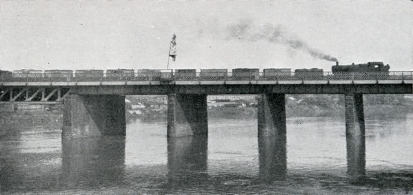
Up mineral train crossing the River Usk bridge at Newport,
which was widened on the northern side when two additional tracks were laid in 1925
Half a mile nearer Newport is Nettle-folds branch, a private siding opened in February, 1875, to serve the Great Western Wharf, which was built to ease the congestion on the opposite bank of the river. The line was at first known as the East Usk branch, and the 25 in. Ordnance Survey of 1899-1900 gives this name to this line and to the Uskmouth line. The Nettlefolds branch throws off another track which runs northwards to serve the former Corporation power station and other works.
The tunnel west of High Street was doubled in 1912 by means of a separate double-line bore on the north side, and in 1925 the river bridge was widened to take four tracks. Power signalling was introduced on May 29, 1927, when the new East Box replaced the former Newport East and Maindee West boxes. It was the first large-scale installation on the Ferreira-Insell system, using miniature four-position levers to set the route and pull off the signals, which are still G.W.R.-type semaphores. Ninety-six levers are provided, 79 of which were required at first; since then, a new connection has been put in from platform 4 to the relief line, and 84 levers are now in use, with 12 spares.
On June 24, 1928, a similar installation was brought into use at the West Box, with 125 working levers and 19 spares, and the Middle Box was taken out of use. The platforms were extended, a new one (No. 8) was provided and a new five-storey building erected on the down side. "Magnificent" was the word used in the Great Western Railway Magazine for June, 1930, to describe the new station, which became a "closed" one about this time. Some 750,000 passengers are now booked there annually, and 300,000 platform tickets are issued.
The lines from Courtybella to Llanarth Street and from Salutation Junction to Dock Street had been closed in 1907, but remained in use as sidings for another 20 years or so. They were then lifted, and the land vacated was used to widen Cardiff Road and provide new roads. The canal to the south of Llanarth Street had been stopped up by powers granted to the Monmouthshire Company in 1879. The Newport Corporation (No. 1) Act of 1930 gave the Town Council power to demand the closing of a further section of the canal and the deviation of about a quarter of a mile of railway on to the canal site. The land vacated by the railway was to be vested in the Corporation, which could use it to build a new road. All this work was carried out, and the new road, named Kingsway, was opened on November 5, 1934. Since then, the railway map of Newport has remained unchanged.
Recent developments include the provision of electrically-operated lifting barriers at the level crossing at Courtybella on December 14, 1959, and the opening on January 25, 1960, of a new signalbox at Dock Street to replace three other boxes. Passenger services in the Sirhowy Valley were withdrawn on and from June 13, 1960, having lasted for six days short of 95 years. Since 1958, there had been only one through train from High Street to the Sirhowy line — at 4.20 a.m.
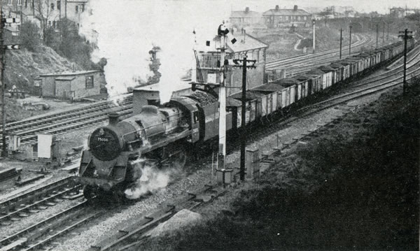
Freight train, hauled by B.R. standard class "4" 4-6-0 No. 75008, passing Gaer Junction,
west of Newport High Street Station
The new Spencer Steelworks, four miles east of Newport, are expected to begin production in 1961 and, partly in connection with this, a £2,000,000 railway scheme was announced early in 1960. Briefly, it is intended to confine passenger trains to the northernmost pair of tracks, and use the island platform at High Street for both up and down expresses, and the down platform for parcels trains only. A new signalbox, now under construction at the east end of the down platform, will take the place of 14 existing boxes and be responsible for 15 miles of track from St. Brides, 3½ miles west of Newport, to Magor and Llantarnam; colour-lights will then replace the semaphore signals which have been a feature of the railway scene for so many years.
I am indebted to many friends for their help in the preparation of this article, and especially to Messrs. D. S. M. Barrie, C. Hadfield and R. G. Vaux.