
Maritime History of Newport
By Peter Brown
© Peter Brown 2024
Dry docks
The Newport ship was an early recorded example of ship repairing in Newport, although that vessel was pulled off the river into an inlet. The 19th century saw the development of several purpose-built dry docks used for the construction and repair of ships:
- Jack’s Pill (from 1830)
- The Alexandra (North) Dock (from the 1880s)
- The Eastern Dry Dock (from the 1880s)
- The Tredegar Dry Dock (from 1898)
Another dry dock was planned for construction parallel to the Sea Lock after the Alexandra South Dock was extended in 1914. The proposed dock was still shown on a dock improvement plan as late as 1928 but was never built.
Shipbuilding had declined by the late 19th century, but ship repairing and engineering were flourishing and continued throughout the 20th century.
Jack’s Pill
The first dry dock at Jack’s Pill, near where the George Street bridge now crosses the river, was built by William Perkins in 1830, and further expansion at this site in 1842 included the construction of a secondary dock by Willmett and Hall.[1]
Jack’s Pill with the first graving dock, shown on the 1845 Tithe Map.
(Newport Past website)[2]
In 1871, work began on an additional dry dock that was opened in June 1872.[3] It was named the Alice Dry Dock in honour of the daughter of the company's chairman, Colonel Lyne, who laid the foundation stone on 15 June 1871. The dock measured 300’, with a depth of 27’ 9”. The masonry of the dock was built of Aberbeeg stone, the blocks for resting the vessels were of iron, and the gates, made of pitch pine, were 28’ 7” high and 54’ wide. The massive stones for the outer work of the walls came from the Forest of Dean.[4] The first ship to enter the dock was the Duke of Newcastle.
This photograph is believed to show the laying of the foundation stone for the Alice Dry Dock on 15 June 1871. Alice was the daughter of Colonel Lyne, the company's chairman; she was 12 at the time and might be the young person with the white hat in the centre of the photo.[5] The other two people in the centre could be Alice’s brothers, Herbert (17) and Ernest (5).
The “foot-way” laid to provide convenient access to the event is also mentioned in the press coverage.[6]
(Unknown source. It should be noted that this photo has also been described on social media as the start of building the Alexandra Docks in 1868.)
A further change of ownership to Mordey, Carney and Co. led to another basin being built in 1888 and the works opening in 1890.[7] The three dry docks were the Mary Dry Dock (350’ x 60’), the Alice Dry Dock (289’ x 46’ 6”) and the Edith Dry Dock (220’ x 36’).[8] In 1899, they acquired a further 40 acres of land for more dry docks and shipbuilding slips.[9] The shipbuilding area became the breaker's yard for John Cashmore Ltd. just before World War I.
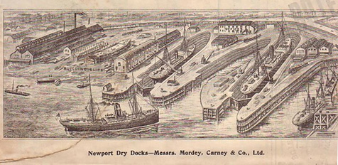
The premises of Messers Mordey, Carney & Co Ltd. at Jack’s Pill, around 1902.
(Newport Past website)[10]
In June 1918, the Russel, Clapps and Risca wharves near the Town Dock were purchased for a new shipbuilding yard, but it seems that the yard was never built as the next recorded shipbuilding in Newport was not until the 1950s at the North Dock.[11]
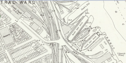
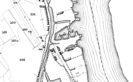
The Mordey and Carney works at Jack’s Pill in 1921. Ordnance Survey 25” map.
(Reproduced with the kind permission of the National Library of Scotland)
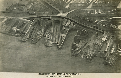
A publicity photo for Mountstuart Dry Docks and Shearmans Ltd. after they had taken over the dry docks in 1922.
(Newport Past website)
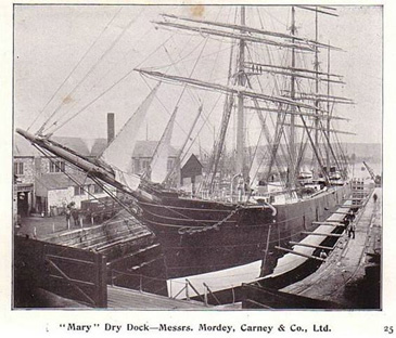
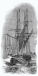
The four-masted steel barque Oceana in Mordey and Carney’s ‘Mary’ Dry Dock, for a chipping off and re-paint in October 1905. Days after the photograph was taken there was a fire at Mordey and Carneys (17 October 1905), in which she was lucky not to catch fire. The Oceana was handed over to Italy as war reparations in 1920 and scrapped at Alicante in 1921.
(Newport Past website)[12]
North Dock Dry Docks
The first stage of the Alexandra Docks was the North Dock, which opened in 1875, although it didn’t have that name until the South Dock was constructed later. The dock was entered from the river by an entrance lock near the south-east corner. By 1883, a graving dock was recorded adjacent to this entrance but at an angle to the dock. This dock measured 523’ x 50’ and was referred to later as the Commercial Dock. It was filled in in 1958.
This plan from 1883 shows the North Dock soon after opening. The original graving dock is to the right of the entrance lock and at an angle to it.
(Newport Past website)[13]
The entrance lock was closed in 1919, following a reduction in use after the Sea Lock was opened in 1914, allowing access to the North Dock via the South Dock. The closed lock was then converted into a dry dock called Messrs. C. H. Bailey’s Dry Dock.[14] This dry dock was extended to 415’ long and 60’ wide by 1934 and later became The Bristol Channel Ship Repairers Ltd. In 1957, it was reported that the owners were raising £500,000 to build a “mammoth dry dock”, 750’ by 100’, which could accommodate ships of up to 45,000 tons.[15] The dock finally closed in 2004, after Bailey’s had been repairing ships for over a century.[16]
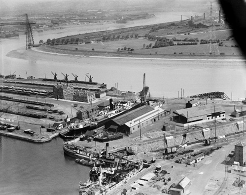
View of a ship in the Alexandra Dry Dock, which used to be the entrance lock. The original graving dock is seen heading off to the right.
Creator: Aerofilms Ltd (01/01/1934)
Crown Copyright: Royal Commission on the Ancient and Historical Monuments of Wales.
Reproduced by kind permission under a Creative Archive Licence.
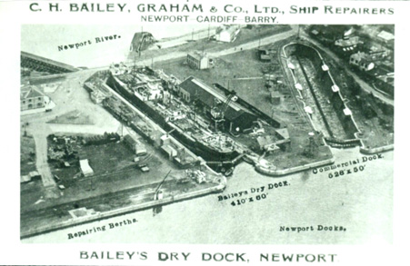
Bailey’s Dry Dock publicity image.
(Source and date unknown)
Bailey’s Dry Dock in 1920.
(Newport Past website)
Eastern Dry Docks
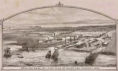
An early print of the first graving dock on the east side of the river.
(Newport Past website)
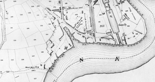
In September 1883, a luncheon was held at the King’s Head Hotel to celebrate the launch of the Newport, Slipway, Dry Dock & Engineering Co Ltd.[17] The company had acquired a large piece of land on the east side of the river opposite the area of the South Dock to construct “a patent slipway, gridiron, wharf, and other large works.” Mr Thomas Beynon was the Chairman of the company. On a map of 1892, it is referred to as the Eastern Dry Dock.[18]
In 1895, it was reported that the Union Dry Dock Company had acquired an extensive piece of land on the eastern bank of the Usk for the construction of a second dock. This was to be larger than the existing dock to accommodate the larger vessels needing work.[19] The second dry dock was informally opened on 13 December 1897, when the steamship Denton Grange (owned by Houlder Brothers) was brought in for a survey.[20] Another map of 1905 records the addition of the second dry dock when they were referred to as the Severn Dry Docks. They were known as the Channel Dry Docks from 1916.
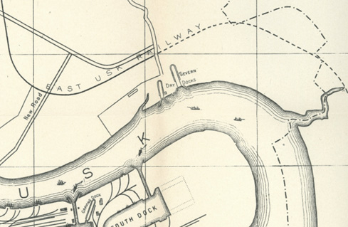
The two Eastern Dry Docks are shown on a plan of 1905.[21]
The docks were owned by the Mountstuart Dry Docks and Shearman's Co from 1922, after the Mountstuart Dry Docks, Mordey, Carney and Co, and John Shearman and Co (of Newport and Cardiff) were all amalgamated as one company.[22] The Mountstuart Eastern Dry Dock at Newport was lengthened (by 55’) to 425’ in 1926 and could accommodate vessels having a beam up to 54’.
Also referred to as the Union Dry Docks, the more easterly (larger) dock was known as the Channel Dry Dock, or No.1, measuring approximately 781’ by 95’, while the western (smaller) dock was known as the Eastern Dry Dock, or No.2, measuring approximately 436’ long by 72’ wide.[23]
The smaller Dry Dock, the Eastern, was used for years as a sand berth operated by Bowles and later British Dredging but ceased operating in the late 20th century. The larger of the two, Channel Dry Dock, was bought by Bell Line of Waterford, Ireland and operated as a container berth, moving containers to and from Ireland and nearby European ports in the 1970s and 80s. It then became Bird Port, loading and discharging mainly steel products to and from the continent for (British Steel) Tata. Simec Ports now own both docks, and the larger one is still used for shipping steel.[24]
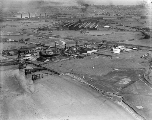
A 1922 photograph of the Eastern Dry Docks.
Reproduced by kind permission of the National Museum of Wales, for educational purposes.[25]
The Union Dry Docks on the east bank, in 1933. The works beyond were the British Mannesmann Tube Works, which later became Stewarts and Lloyds.
Creator: Aerofilms Ltd
Copyright Crown Copyright: Royal Commission on the Ancient and Historical Monuments of Wales 2023.
Reproduced by kind permission under a Creative Archive Licence.
Tredegar dry dock
This dry dock was built in the Pillgwenlly Pill, which had been developed as the Tredegar Wharf in the early 19th century.
Part of the 1845 Tithe Map showing the Tredegar Wharves at the Pillgwenlly Pill before the Tredegar Dry Dock was built.[26]
The Tredegar Dry Dock and Wharf Co was registered in 1898,[27] and the dock was built at the end of Commercial Road, where it meets Alexandra Road and Mill Parade, occupying the site of the earlier Tredegar Wharf. Sigismund Frech, the resident engineer for the construction, published a detailed account of the dock in 1907 after it had been completed in 1903.[28]
The dry dock was 712’ long, 80’ wide at the entrance, and one of the largest in the port. It could accommodate ships of 12,000 tons and was divisible into two sections by middle gates so that two ships of 7,000 tons could be docked at the same time. The impressive equipment included a pumping plant to clear the water within two hours.
The repairing quays and wharves had a river frontage of 600’ with deep berths and were equipped with five locomotive cranes of quick capacity. Rail lines connected the dock to the Great Western Railway (GWR) and the Alexandra Dock Company’s line. Further technical details of the dry dock in 1914 can be seen here.[29] The principal cargoes imported at the adjacent Tredegar Wharves in 1914 included pitwood (used for pit props in mines), iron ore, pyrites and continental cargoes. By 1934, this dry dock had also passed into the ownership of Mountstuart Dry Dock Company[30] and continued in use until the 1960s before the site was repurposed.[31]
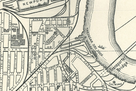
The dry dock on a 1905 plan of Newport.
(Newport Past website)
Tredegar Dry Dock and Wharves and Uskside Engineering, with Commercial Road and the Town Dock in the background (no date).
Copyright Gwent Archives. Reproduced by kind permission of Gwent Archives. / Hawlfraint Archifoedd Gwent. Atgynhyrchwyd drwy garedigrwydd Archifoedd Gwent.
Creative Archive Licence
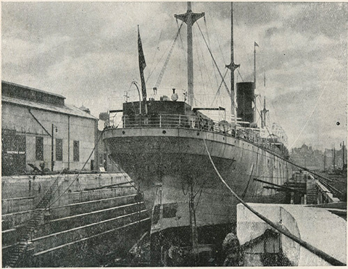
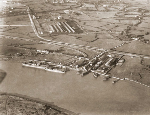
Tredegar Dry Dock in 1914, showing the Oswestry Grange of 10,000 tons.[32]
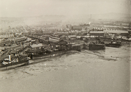
A 1947 aerial photograph showing the Tredegar Dry Dock in operation at the bottom centre.
(Origin unknown)
The Alexandra South Dock
The South Dock and Sea Lock were completed in 1914, and the infrastructure at the lock allowed for a dry dock to be constructed parallel to the lock and just to its west.[33] The proposed dock was still shown on a 1928 sketch map of improvements to Newport Docks, but it was never built.
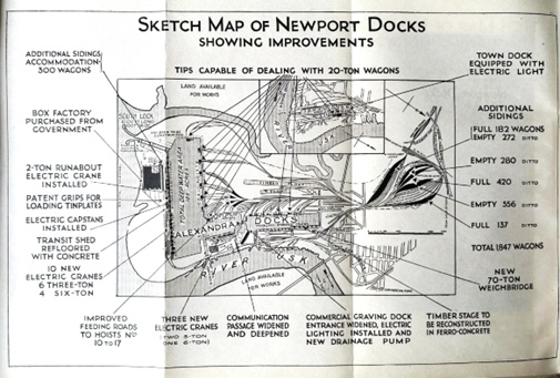
This 1928 map shows the improvements, and the proposed dry dock next to the Sea Lock is shown as “to be constructed”.
(Courtesy of Richard Wood)
References
1 Maylan C. N. (1991) Proposed Usk Barrage Initial Archaeological Assessment, GGAT Report No. 91/01, 18.
Online at: https://walesher1974.org/her/app/php/herumd.php?level=2&group=GGAT&docid=301464088&linktable=her_source1_link
2 https://www.newportpast.com/gallery/maps/tithe/tithe1.htm
3 Western Daily Express, 30 May 1872. (British Newspaper Archive).
4 The Evening Telegram, 15 June 1871. (British Newspaper Archive).
5 1871 census.
6 The Evening Telegram, 15 June 1871. (British Newspaper Archive).
7 Howell, J. K. and Dunning, R. (2004) Urban Waterfronts in southeast Wales: Phase 1, Desk-based assessment, GGAT report no. 2004/075, 126, citing Maylan (1991).
8 Hutton, John (1996) The Newport Docks & Railway Company, 26.
9 Dawson, J. W. (1932) Commerce and Customs: A History of the Ports of Newport and Caerleon, 84.
Online at: https://archive.org/details/commerce-and-customs-newport
10 https://www.newportpast.com/gallery/prints/dry_docks.html
11 Knight, Cliff (1985) Pillgwenlly, Newport: The Changing Times, 56.
12 https://www.newportpast.com/gallery/photos/php/photo_page.php?search=Oceana&search2=yyyyyy&pos=1
13 https://www.newportpast.com/gallery/maps/m1883.htm
14 https://www.southwalesargus.co.uk/news/19484698.destroyed-newport-dock-port-office-photos/
15 Western Mail, 1 August 1957. (British Newspaper Archive).
16 https://www.flickr.com/photos/oldmanbigkid/14135546731/
17 Western Mail, 4 September 1883. (British Newspaper Archive).
18 https://www.newportpast.com/gallery/maps/m1892.htm
19 South Wales Weekly Argus and Monmouthshire Advertiser, Saturday 7 December 1895. (British Newspaper Archive).
20 Cardiff Times, 18 December 1897. (British Newspaper Archive).
21 https://www.newportpast.com/gallery/maps/m1905.htm
22 https://www.gracesguide.co.uk/Mountstuart_Dry_Docks
23 https://coflein.gov.uk/en/site/403431/
24 We are grateful to Alan Malpas, Tony Deacon and Rhys Davies for their help with the recent history of the Eastern Docks.
25 https://museum.wales/collections/online/object/a5298969-c95e-35f1-96d3-310d6b2c738c/?field0=string&value0=pattern&field1=with_images&value1=1&page=28&index=329&_gl=120vg4h_gaMTc2NTQwMzE0NC4xNzAxNjkzMjI5_ga_Q4211BYX1VMTcwMTY5MzIyOS4xLjEuMTcwMTY5MzIyOS4wLjAuMA..&_ga=2.168392937.913165836.1701693230-1765403144.1701693229
26 https://www.newportpast.com/gallery/maps/tithe/tithe1.htm
27 https://gracesguide.co.uk/Tredegar_Dry_Dock_and_Wharf_Co
28 Frech, S. A. (1907) ’The Tredegar Dry Dock, Newport, Monmouth’, Minutes of the Proceedings of the Institution of Civil Engineers, 167, 271-285.
Online at: https://zenodo.org/records/2236895
29 https://www.newportpast.com/gallery/photos/php/photo_page.php?search=alexandra%20dock&pos=122
30 Hutton, 26.
31 We are grateful to Alan Smith, Richard Mansfield, Carol Stock and Phil Brawn for their help with dating the closure of this dry dock.
32 http://www.newportpast.com/gallery/photos/php/photo_page.php?search=dry%20dock&search2=yyyyyy&pos=4
33 Information from Mark Giblett at the ‘Newport Docks & River Wharves’ group on Facebook.
Back to Index of Peter Brown's "Maritime History of Newport "