
Maritime History of Newport
By Peter Brown
© Peter Brown 2024
The development of the river wharves
During the later 19th and 20th centuries, Newport shipping was dominated by the Town Dock and the Alexandra Docks. However, the river wharves still contributed significantly to the Town’s shipping, firstly along the west bank and later the east bank as well.
West bank
From Medieval times onwards, the main wharves were situated on the river's west bank, close to the Town Bridge and the Town Pill, but during the 18th century these were extended further south to accommodate increased demand. Still, following the arrival of the Monmouthshire Canal in 1796, the vast increase in shipping required a more significant expansion of wharves southwards.
A plan of 1837 shows the canal travelling down through Pillgwenlly to the basin in Church Street, which opened in 1808, before the significant housing development in Pill. The plan reveals a lot of riverside development between the Town Bridge and the inlet at Jack’s Pill, where Cashmore’s breaking yard was later situated. Another cluster of activity shows around the Pillgwenlly Pill further south, where the Tredegar Dry Dock was later built.
A cropped version of the 1837 plan showing the canal and riverside wharves.
(Newport Past website)[1]
Next to the Town Bridge and the Bridge Hotel was the Steam Packet Jetty, probably on the site of the first steam packet service to Bristol that began in 1822, and photos from around 1890 show this jetty still in use. It is shown on the town plans up to 1953, but is missing from a plan of 1960 where the Bristol Packet Wharf is marked further south below where the Riverfront Theatre stands today. The 1870 survey (see below) shows a separate Steam Packet Jetty across the river on the wharf site used by Campbell’s steamers.
The Steam Packet Jetty seen in about 1890.
(Unknown source)
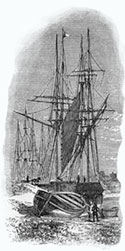
The Welsh Prince is loading at the Bristol Packet Jetty while passengers look on. The boat belonged to the Bristol and Newport Screw Steam Packet Company. Daily services ran between Newport and Bristol carrying passengers and goods, but the service stopped in 1886 due to competition from the newly opened Severn Tunnel.
The Welsh Prince continued operating in the Channel until 1930, when she was scrapped at Cashmore’s.[2]
(Image courtesy of the Friends of Newport Museum and Art Gallery)
The Tithe Map of 1845 provides much greater detail of the wharves along the river, right around Pillgwenlly and even south of the Pillgwenlly Pill. This was just after the Town Dock had opened but before most of the houses had been built on the marshland of Pillgwenlly.
ZOOMABLE MAP!
The north and south sections of the western riverbank are shown on the 1845 Tithe Map.
Notice how the quaysides extend from the town bridge to down beyond Llanarth Street, where they are replaced by jetties all along the riverfront. This includes the northern section of the Town Dock, even though that did not open until 1858.
(Newport Past website)[3]
Shortly after the Tithe Survey, Scott’s History of Newport published a list of the coal and iron wharves in 1847:[4]
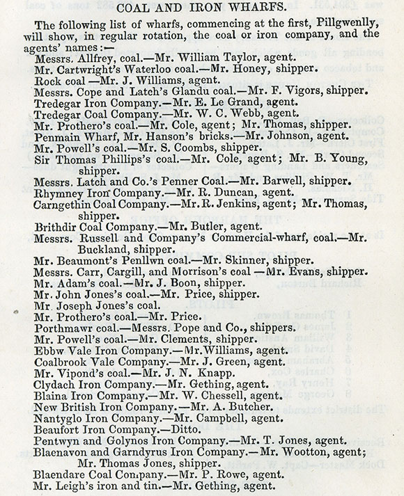
Scott’s list of coal and iron wharves in 1847.
This 1854 plan shows the area of the Pillgwenlly Pill and the canal basin next to the Town Dock, with all the jetties and connecting railways.

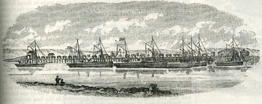
View from the Railway Bridge by James Flewitt Mullock, around 1860.
This view shows the scale of the river traffic soon after the Town Dock was completed, with sailing ships all along the riverbank and a steamship leaving the jetty and probably heading to Bristol.
(Newport Past website)
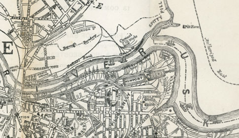
The most detailed survey of the river Usk was made in 1867 by Captain Alldridge for the Newport Harbour Commissioners, with additions in 1870.[5] This survey shows the names of all the wharves along the river down to the Cork Steam Packet Wharf near the Alexandra (North) Dock that was then under construction. It is reproduced here as a zoomable map:
ZOOMABLE MAP!
In 1871, the Chamber of Commerce notified the Commissioners of Customs about the restrictive effect of the regulations prohibiting the shipment of coal, iron, and other goods to foreign countries at unapproved wharves.[6] At the time, there were 4 legal quays and 9 sufferance wharves approved for imports and exports, and 14 sufferance wharves approved for exports only. The legal quays were the named quaysides where cargoes could be loaded and unloaded during regulated hours.[7] The sufferance wharves were licensed private wharves where dutiable goods could be kept until the duty was paid. These facilities were inadequate for the demand, and the Commissioners approved the grant of suffrage privileges for shipping coal and iron to any wharf without a bond being required. Thirty-nine wharves took advantage of this concession on the west bank of the Usk.
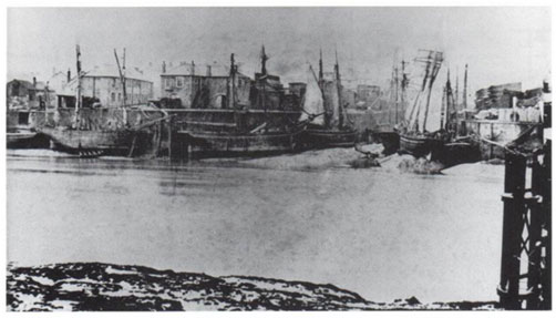
Ships on the western bank at the entrance to the Town Pill in 1880.
In the collection of Newport Museum and Art Gallery.
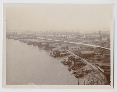
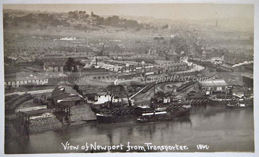
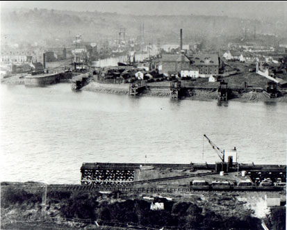
This view from the Transporter Bridge shows the river wharves with the Alexandra Docks beyond soon after 1906.
Reproduced with the kind permission of Gwent Archives, under the Creative Archive Licence for non-commercial educational use.[8]
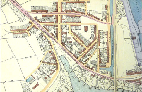
Wharves near the Transporter Bridge and the Pillgwenlly Pill around 1910.
(Newport Past website, photo by Patrick White)
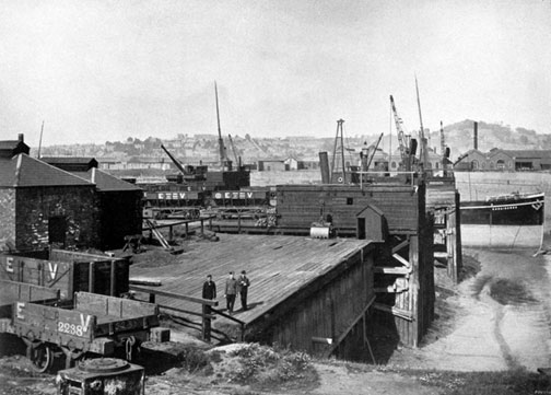
The Ebbw Vale Steel, Iron & Coal Co. owned four wharves at Newport to import iron ore and pit props and to export iron and steel. This photo shows one of the wharves in the early 20th century.
Publisher Ref: museumwales.ac.uk/media/11937
Reproduced by kind permission of the National Museum of Wales under a Creative Archive Licence for non-commercial educational use.[9]
The development of the eastern bank
With the main quays and the floating docks all on the western side of the Usk, less attention tends to be paid to using the river's eastern bank. The east bank was largely undeveloped until the later 19th century and consisted of open fields protected by a sea wall, like the western bank in Pillgwenlly.[10] In 1851, the area just south of the bridge became Rodney Wharf, and by 1870, it was shown as a Steam Packet Jetty like the earlier one on the west bank next to the Town Bridge. Further south, two jetties were constructed to allow the unloading of ballast,[11] and these ballast banks are marked on the 1847 plan of the town.[12]
In 1864, Thomas Spittle started the Cambrian Engineering Works and shipyards near the area of the rugby ground in Rodney Parade. By 1881, the Rodney Wharf there had been improved by adding a pontoon into the river, and south of this, the Harbour Commissioners had erected a jetty called the Grid Iron, which allowed maintenance on vessels at low water.[13] It was 250’ long and 37’ wide, affording 16’ at spring tides.[14]
Some way south of the town bridge is an inlet known as Spytty (or Lliswerry) Pill, which survives just north of the Southern Distributor Road and opposite the site of the Town Dock. This inlet was a natural location for early shipping to dock, and a court case in 1774 shows that timber was stacked on the eastern bank of the Usk awaiting shipment, suggesting a jetty was already there for offloading the timber.[15]
This 1889 plan shows the location of the Great Western Wharf opposite the Town Dock soon after its construction in 1875.
(Newport Past website)[16]
A new town called Port Gwent was proposed for this area in 1859, but there is no evidence that work commenced.[17] In February 1875, the Great Western Wharf on the east bank of the Usk, opposite the Town Dock, was constructed for handling free goods in bulk (like on the west bank), handling 30,000 tons of Spanish ore per year for transit to Staffordshire.[18] The Wharf also had a private railway communicating with the Great Western Railway and was described this way in 1893:[19]
There is a magnificent plant, comprising four large steam cranes, capable of discharging one thousand tons per day; a keel berth of five hundred feet in length, and a coal staith with appliances for shipping from eight hundred to one thousand tons of coal per day. The rolling stock includes two powerful locomotive engines, and about five hundred wagons used for the conveyance of minerals and heavy goods, principally for the leading collieries and iron works of South Wales and Monmouthshire. A large business is done with the works at Rogerstone, Tydu, Blaina, Ebbw Yale, Dowlais, Risca, Cwmbran, Pontymister, Aberbeeg, Abertillery, Panteg, Pontnewydd, Blaenavon, Abersychan, Pontypool, and other centres, which are conveniently situated in the district, for the conveyance to and from the wharf. The chief imports are iron ore from Spain, iron pyrites, pig iron, pitwood, &c., whilst there is an enormous export of the celebrated Welsh steam coals, artificial manures, and all classes of heavy goods.
Great Western Wharf and Railway in 1893.
(Newport past website)
In the foreground is the wharf built for Lysaghts Steelworks in 1899.
Opposite is the Town Dock with its entrance lock, ancillary buildings and wharves along the riverbank.
(Source unknown)
The decline of the river wharves
A symbolic event in the decline of the river wharves came in 1915 when the canal stopped supplying the wharves; the last barge to the Moderator Wharf was photographed for posterity in 1915 when the service stopped after 119 years. The railways still supplied the wharves for some years after, although the lines from Courtybella along Cardiff Road to Llanarth Street (past Ebeneezer Terrace) and through George Street had already closed to most traffic in 1907 but remained in use as sidings for another 20 years or so.[20] The remaining railway lines servicing the town wharves slowly reduced in use over a long period.
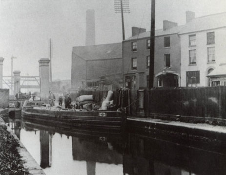
The last barge was at the Moderator Wharf in 1915.
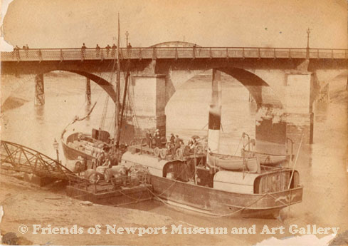
After the closure of the Town Dock in 1930, many of the wharves along that part of the river were abandoned. Use of the river wharves continued to decline, and in 1957, the Campbell’s Steamers Wharf near Rodney Parade was discontinued, and the 61-year-old landing stage was towed away for reinstallation at Rotterdam.[21] A plan of around 1960 named the river wharves that were still functioning, and the river traffic slowly decreased over the following years while the railway network serving the wharves was gradually removed.[22]
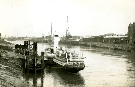
This 1956 photo shows the Glen Usk at the Campbell’s landing stage in 1956, just before its removal. Of the shipping facilities along the river, almost nothing survives today.
(Photo by Jim Brown)
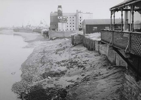
A view of the original quayside from the Town Bridge just before the river traffic ended.
(Unknown photographer)
References
1 https://www.newportpast.com/gallery/maps/m1837.htm
2 https://www.newportship.org/wp-content/uploads/2018/02/SOS_11.pdf
3 https://www.newportpast.com/gallery/maps/tithe/tithe1.htm
4 Scott, J. M. (1847) The ancient and modern history of Newport, Monmouthshire, 108-9.
Online at: https://play.google.com/books/reader?id=6fDBCw31psEC&pg=GBS.PP1&hl=en
5 https://www.newportpast.com/gallery/maps/river_usk_1870.htm
6 Dawson, J. W. (1932) Commerce and Customs: A History of the Ports of Newport and Caerleon, 80.
Online at: https://archive.org/details/commerce-and-customs-newport
7 https://en.wikipedia.org/wiki/HM_Customs
8 https://www.peoplescollection.wales/items/7200
9 https://www.peoplescollection.wales/items/19418
10 Maylan C. N. (1991) Proposed Usk Barrage Initial Archaeological Assessment, GGAT Report No. 91/01, 22 and 28.
Online at: https://walesher1974.org/her/app/php/herumd.php?level=2&group=GGAT&docid=301464088&linktable=her_source1_link11
11 Maylan, 1991, 28.
12 https://www.newportpast.com/gallery/maps/wharfs1847.html
13 Maylan, 1991, 28.
14 Details from the 1870 map of Newport http://www.newportpast.com/gallery/maps/river_usk_1870.htm
15 Maylan, 1991, 22, citing TNA Exch. Bills and Answers: Monmouth, Trinity, 18 Geo. III, No. 66.
16 https://www.newportpast.com/gallery/maps/m1892.htm
17 Maylan, 1991, 22.
18 Dawson, 81.
19 Anon (1893) ‘Great Western Wharf and Railway, East Bank of River Usk, Newport (Mon.)’, The Ports of the Bristol Channel, London: London Printing & Engraving.
20 Skillern, W. J. (1960) ‘The Railways of Newport’, The Railway Magazine, July 1960, No. 711, Vol. 107.
Online at: https://www.newportpast.com/transport/rail.php
21 https://www.newportpast.com/hd/chronology.htm#1950
22 https://www.newportpast.com/gallery/maps/m1960ish.html
Back to Index of Peter Brown's "Maritime History of Newport "