Search Results
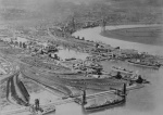
Aeroplane View of Newport
Original text: "The water space in the foreground of the picture is a portion of the Alexandra Dock, which has a total area of 125 acres. In the foreground and also on the left side of the Dock are the coal tips, which lift up to 70 feet from quay l...
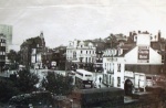
The Castle Hotel and Old Green Crossing
This view appears to have been taken from the railway bridge. We are looking at the junction of Shaftesbury Street, High Street, Dock Street, Kingsway and Newport Bridge / Clarence Place.
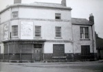
The Railway Hotel
80 Dock Street.

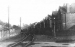
Crindau Sidings Signal Box

Albany Street off Malpas Road
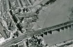
Aerial Photo - Mid 1920s
The temporary road bridge is in place which dates the picture to the mid 1920s. Castle grounds are in use. Good view of the top of Shaftesbury Street.
Cardiff Road
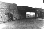
Railway Bridge Over Shaftesbury Street / Malpas Road
We are looking towards Malpas. On the right is Edwin Street, and the bottom of Barrack Hill can be seen the on the left beyond the bridge. Note the tram lines for the Stow Hill - Malpas route.
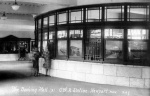
The Booking Hall, High Street Railway Station
Postcard view.

Railway Strike 1911
Arrival of troops at Maindee Junction August 19th 1911.