Search Results
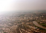
Aerial Photo Late 1990s
(From a private collection.)
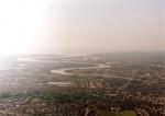
Aerial Photo Late 1990s
(From a private collection.)
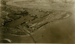
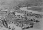
Aerial View Alexandra Docks Great Western Railway
Postcard - The Autotype Co Ltd.
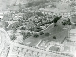
Aerial View West Newport
Belle Vue Park, Cardiff Road, Royal Gwent Hospital, The Friars, Belle Vue Lane, Friars Road and St Woollos Hospital.
Aeroplane View of Newport
Original text: "The water space in the foreground of the picture is a portion of the Alexandra Dock, which has a total area of 125 acres. In the foreground and also on the left side of the Dock are the coal tips, which lift up to 70 feet from quay l...
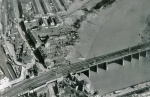
Aerial Photo - Mid 1920s
The temporary road bridge is in place which dates the picture to the mid 1920s. Castle grounds are in use. Good view of the top of Shaftesbury Street.
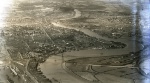
Aerial Photograph of Newport (North) - Early 1920s
Scanned from an original glass negative. Photograph taken in the early 1920s by Arthur W Hobart. Had been stored in an envelope titled "From Below Transporter to Caerleon". Work has not commenced on the 'new' Town Bridge - no sign of the temporary...
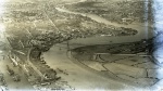
Aerial Photograph of Newport (South) - Early 1920s
Scanned from an original glass negative. Photograph taken in the early 1920s by Arthur W Hobart. Had been stored in an envelope titled "From Below Transporter to Caerleon". Work has not commenced on the 'new' Town Bridge - no sign of the temporary...
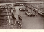
Aerial View Of South Dock, Newport, Coaling and General Cargo Quays
From "The Newport Harbour Commission Centenary June 21st 1936" published by RH Johns.
Aerial Display Team Flying Under the Transporter Bridge
Photo taken around 1983. Photo Ron Sutcliffe.