|
Stow
Hill
©
Bob Trett 2010
The
first settlement (before the Norman foundation of Newport)
was on Stow Hill. The name "Stow" shows Anglo-Saxon
connections with the area, but the original settlement by
tradition relates to St Gwynllyw (St Woolos) founding the
church in the fifth or sixth century. After the Norman Conquest
Robert fitz Hamon seized Wentloog, and the settlement is
thought to have expanded down Stow Hill, and the new borough
established by the town bridge. At some point a castle was
built to protect the bridge and the town.
St
Woolos Church
(SMR references 220468
& 08205g ST 33090 18760)
According to the early 13th century manuscript ‘The Life of S. Gundleus’ [1] and other early accounts, the church of St Gwynllyw (later corrupted to Woolos) was founded by the Welsh ruler St. Gwynllyw in the fifth or sixth century, after his conversion to Christianity. A chapel dedicated to his wife, Gwladys, allegedly stood by the crossing of the Ebbw River, on the southern slopes of Stow Hill. These accounts were written centuries after the events they describe, and rely mostly on the oral tradition passed down the generations by Welsh bards. They are also contradictory at times but it is clear that the name Gwynllyw gave its name to the Welsh cantref known later as Wentloog.
There are many other published descriptions of the church and its contents, so these are not repeated here. [2] The earliest surviving parts of the church (the present St Woolos Cathedral) date to the Norman period. The decorated archway in St Mary’s Chapel with its naively carved capitals, together with the five-bay nave of the main church, are twelfth century, with the walls of the chapel believed to be thirteenth century, and the tower late fifteenth century. The statue of a knight on the tower is thought to be the then lord of Newport, Jasper Tudor, earl of Pembroke and duke of Bedford. It was once thought to represent St Gwynllyw himself, but a Tudor rose and other designs under the parapet of the tower suggest it could be Jasper. Other parts of the present cathedral are post-medieval or modern.
The church suffered badly during the Puritan period after the Civil War, when much was lost. It is interesting to note that a decorated stone arch (ogee) and other foliate carvings have been reused in a garden wall in the nearby house called Bishopstowe.
After the establishment of the new borough (Newport) the church remained just outside, within the manor of Stow. The 1427 charter given to Newport identifies the graveyard of St Woolos as being on the boundary of Newport. At the end of the eleventh century the church was given to the monastery of St Peter at Gloucester by Robert de Hay. The church was at times the centre of disputes over its rights, but it remained the parish church for the borough.
The road from Newport Bridge through Newport High Street and Stow Hill split just above St Woolos Church. One road (now Friars Road) was the former way to Cardiff, whilst the other road along Stow Hill went to Bassaleg. This was a probable second route to Cardiff as well as to the north of the lordship via the Ebbw Valley, and also to Caerphilly.
1. British Library MS. Cotton. Vespas D.xxii
2. Knight, J.K. and Wood, R. ‘St Gwynllyw’s Cathedral, Newport: the Romanesque archway.’ In Archaeologia Cambrensis 155 (2006) 163-185, give an excellent descriptions of the medieval remains and the documentary sources. However the claim that the Romanesque archway is supported on reused Roman columns is disputed. A report is in preparation by B. Trett, M. Lewis and J. Allen, suggesting the alternative view that the columns are contemporary in date with the rest of the archway.
The
Tithe Barn
(SMR reference 00157g ST
33087 18756)
Around the south side of the church was a small cluster of houses including the tithe barn which is on the site of offices currently belonging to Kier Western. A building south of the church and probably the tithe barn, is shown on a Survey of Newport in 1752 by Thomas Thorpe. The barn is again shown on the tithe map of 1845 and is described in the apportionment as the ‘Rectorial Tithe Barn and Yard, 24 perches in size, occupier William Jones’. It is also marked on the 1/500 Ordnance Survey map surveyed in 1881. A wall of stone rubble with some partly dressed stone blocks can still be seen from the road facing the church. Some of the stone work seems to be almost a crude chequer pattern of grey and red sandstone, although recent building improvements make this less obvious.
In the twentieth century Fred Hando gave this description of the tithe barn:
Little of interest survives in the barn. Two old doorways blocked in; two windows with wooden frames cut in imitation, probably, of the original stone mullions and tracery; roof timbers hidden above modern casing; a chimney-breast in the east wall which contains some interesting and massive mouldings and one corbel – that is all. [1]
Disputes over tithes are mentioned in documents in 1146, 1239 and 1255. In 1321 Hugh Audley is said to have burnt some barns at Newport, although it is not known whether these included the tithe barn.
It is also possible that another substantial building was adjacent to the tithe barn. M.G.R. Morris, in an article on Kingshill, Newport shows a watercolour of Stow Hill, looking from the south and dating to around 1830. [2] Close examination of the watercolour shows one or possibly two buildings, with a red roof on the right half and a grey-roof on the left half. There is a chimney on the right (red-roofed) gable-end wall. The wall fronting this part of the building has a number of square windows, a possible door and also a low red-roofed lean-to. There appears to be a small single storey cottage or other building behind the main building.
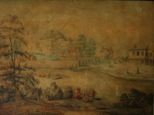
Above watercolour showing Kingshill, St Woolos and possible tithe barn.
Below cropped picture.
(By kind permission of the Bishop of Monmouth)
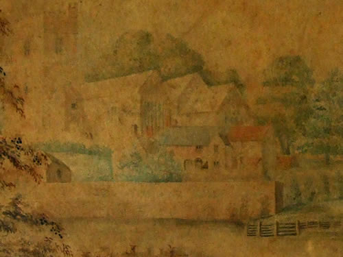
In front of the red-roofed building is a tower-like projecting wing of two storeys containing mullioned windows, and possibly a lean-to or steps on the left side of the projection, running to the first-floor. There is a chimney attached to the side of the projection and it has a pitched roof at right- angles to the roof of the main building. This projecting wing appears similar to the one on the surviving late medieval hall of Tredegar House.
Although the red-roof may appear to be attached to the grey roof it seems likely that the grey-roofed section is the tithe barn, and a separate building. It is also evident that the eaves of the left grey-roof section are lower than the right red-roofed section, although the ridge of both roofs is at the same height in the picture and appears continuous.
The grey-roofed section (the possible tithe barn) has another chimney on its gable-end wall. This building also has a large doorway with a semi-circular arch. This arch is directly beneath another mullioned window. On the left of this doorway is a second, large doorway with a depressed arch. The gable end of further buildings can be seen to the left of the complex.
If the watercolour is at all accurate this must have been an important complex of buildings. Their location is not clear but a possible position for the red-roofed building is on or near the site of the vicarage, the later deanery (ST 33092 18755). The vicarage was built in 1845 as testified by a date stone on the wall. It was also stands on a terrace, similar to the one depicted on the painting.
However in 1800 William Coxe was staying with the vicar of St. Woolos at Caerau House, some way away, and the 1845 tithe map shows the site of the 1845 vicarage as an empty field (number 305 on the map). Nevertheless the apportionment refers to this field as the ‘vicarial glebe’ and ‘the site of Glebe House’. It is therefore possible that the painting does portray an earlier vicarage (glebe house) with the tithe barn behind it.
Barber, C. (editor) Hando’s Gwent Volume II. (Abergavenny 1968) 144
Morris, M.R.G. ‘Kingshill, Newport’ in The Monmouthshire Antiquary XXI (2005) 92
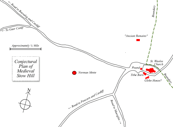
Stow
Hill Motte
(SMR
reference 00157g ST 33048 18743)
A mound used to stand in the grounds of what is now the Springfield Day Centre of St Woolos Hospital, and in what used to be the grounds of the Springfield House. This site overlooks The Severn, on the southern side of Stow Hill. In 1772 William Harris noted ‘a lofty tumulus upon which trees were growing standing by St Gwynllyw’s church and that earthworks associated with it seemed to surround the church’. [1] In view of the distance it would appear highly unlikely that these earthworks by the church had a direct link with the mound. The mound is clearly shown on the 1845 tithe map, standing alone in the middle of a field.
According to Octavius Morgan the mound was traditionally believed to be the burial place of St Gwynllyw, and was covered by spoil from the railway tunnel which runs underneath. The summit of the mound was flat and exactly 50 feet in diameter. [2] Other eighteenth century writers, including William Coxe, refer to it as the ‘barrow called Twyn Gwnlliw’. However it is probable that the mound was not a barrow but a castle motte, probably twelfth century. This motte was possibly the precursor of the present Newport Castle by the river. It would have had a timber keep on top of the mound, and possibly a bailey with a timber palisade.
Coplestone-Crow, B. 1998 33
Morgan, C.O.S. ‘History and Descent of the Lordship of Wentllwch’ in Archaeologia Cambrensis Vol.II. (1885) 261-262
The
Stow Manor Pound
(ST
33082 18759)
This is shown on a map of Newport of 1752 by Thomas Thorpe, where it is located to the west of the tower of St Woolos Church, just outside the churchyard.
Presumably because of an extension to the churchyard the pound had been moved by 1845. The 1845 tithe map shows it much further to the west of Stow Hill and beyond the then Union Poor House (at ST 33041 18755). This later pound is marked as ‘Manor Pound 1½ perches, owner Sir Charles Morgan Baronet’. (See the tithe map and search the 'apportionment' database.)
The Manor House
William Rees states: ‘The manor of Stowe had its manor-house with barn, ox-house, pigeon cotes and fishpond. The lord’s share of the arable land here was about 150 acres; it was not a large manor’. [1] However no site for this has yet been identified. Possibly the ‘Ancient Remains’ could be the location. It is unlikely that the manor house was next to the tithe barn as this was glebe land not demesne land.
1. Rees, W., 1930 ‘Medieval Gwent’ in Journal of the British Archaeological Association 35 (1930) 204
'Ancient Remains'
(ST 3308 1878 approx.)
The first Ordnance Survey map of 1833 shows a large double-banked rectangular feature marked ‘Ancient Remains’ to the north of Stow Hill, approximately at the junction of the present St Woolos Road and Jones Street. The site is marked on an 1837 map of Newport (showing proposed changes to the municipal boundaries of Newport) as an oval shaped mound. (View the map) These ‘Ancient Remains’ are outside the earlier boundary of Newport and are in the Manor of Stow. A field shown on a map entitled ‘Plan of Newport from actual Survey 1836’ shows a kink in its boundary corner at the same location. The 1845 tithe map of the area shows this location to be at the junction of four fields, with the most northern field (marked 297) having a protuberance on its boundary at the spot. No function can be attributed to this feature. (View the tithe map and apportionment)
Stone Quarry
(SMR 00168g ST 330900 187700)
The accounts for repairing Newport Castle in 1447/8 refer to a payment to Thomas Galett for the digging and carriage of ‘wall-stone’ from the ground of the lord near Stowe, formerly of the Abbot of Keynsham. [1] This has been assumed to be ‘Church Field’, later to be the burial ground for St Woolos Church, and now a small park. It is likely that most of the sandstone used in the buildings of medieval Newport was quarried from Stow Hill and other surrounding hills.
Pugh, T.B. (1973) 227 and 229
The
Wayside Cross
(SMR 00209g ST 33101 18789)
10
on the conjectural view of Medieval Newport
The base of a medieval cross stood on Stow Hill on the north corner of Havelock Street. The base has now been removed to the churchyard of St Woolos Cathedral. It has probably wrongly been associated with the ornate head of a fifteenth century cross found in the River Usk near Newport Bridge in 1925. This cross head represents the Crucifixion with what appear to be the Virgin Mary, St John, St Catherine and St Margaret. The head is now in Newport Museum, with a modern replica of the cross standing in Newport High Street. [1]
Gray, M., 2004 ‘Wayside Crosses in Monmouthshire’ in The Monmouthshire Antiquary XX (2004) 64
The House of Refuge or School
(ST 33104 18780)
This building once stood at 69 Stow Hill, where there is now a car park. It can be seen in an old photograph of Stow Hill in Newport Museum and Art Gallery. [1]
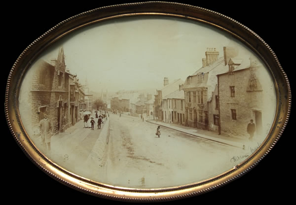
(By kind permission of Newport Museum and Art Gallery)
According to J.M. Scott writing in 1847:
The present House of Refuge on Stow Hill, a broad, high building, was built by the Earl of Pembroke in 1410, in the reign of Henry the Fourth, and made an institution for the education and support of the poor children of the town. He gave to maintain it, certain lands, which, however, now belong to the baronial estate of Tredegar. Above the entrance doorway to this day stands the Pembroke coat of arms, which has suffered in common with other reliques of the past. The building still maintains its charitable character, for it now feeds the hungry, and gives rest and comfort to the homeless. [2]
The coat of arms
The photograph shows the left end of the building, with a triangular stone containing a coat of arms above a door. There are two storeys with further dormer windows in the roof. The walls appear to be of stone rubble and a ground-floor mullioned window appears to have been blocked in and then replaced by a smaller square window. There are stress relieving arches over the downstairs window and the door. The doorway has a Tudor type arch.
Next to this building, on the left side, is a much smaller cottage which would have been 67 Stow Hill, although both have been demolished. However the outline of the roof of 67 Stow Hill can still be seen on the side wall of 65 Stow Hill.
The minute book for the Overseers of the Poor records that on October 31 1774 the overseers were ordered:
to execute ... a Warrant on Distress to levy, the same for rent due on a tenement belonging to the Freemen of the Town of Newport, commonly called the Free Schools.
In 1775 Francis Grose noted:
Passed by a public Grammar School adorned with the arms of some peer or the royal ones, it is now in ruins. [3]
On December 16th 1783 the Overseers of the Poor agreed to the:
repair and fitting the Free School ... into a Workhouse for keeping to work and maintain the poor. [4]
It seems likely that this is the same building as the House of Refuge, which was rebuilt in 1892, and this new building was still used as a House of Refuge in 1901.
A date of 1410 for the original building does not look possible, and at that time there was no earl of Pembroke. Later on the Herbert family were earls of Pembroke and lords of Newport. William Herbert was made 1st earl of Pembroke (of the second creation) in 1551. The coat of arms of the Herberts used three lions rampant. The coat of arms visible on the photograph of the House of Refuge is unclear, but it may include only one lion rampant.
However one of the early aldermen of the Borough, William Williams, conveyed certain properties in trust to his fellow aldermen to endow a Free School on 8th June 1607. These properties included land at Kingshill, adjacent to the school. He is the probable benefactor and founder of the Free School at 69 Stow Hill. [5]
1. Newport Museum and Art Gallery accession number NPTMG 56.119
2. Scott, J.M. The Ancient and Modern History of Newport (Newport 1847). 52.
3. Information from Julian Mitchell from a forthcoming article on the travel journal of Francis Grose
4. Warner, J. Article published in the South Wales Argus April 18th 1932
5. Jones, B.P, (1957). 194-195 note 8.
©
Bob Trett 2010
|